
Walden Environmental Engineering, in partnership with Harkin Aerial, has completed a recent project funded by the Nassau County Soil and Water Conservation District to improve the waterways of Nassau County through their 2020 grant and assistance programs.
In January 2021, members of the project team, including Walden, Harkin Aerial, and the Cornell Cooperative Extension of Suffolk County (CCE), joined together with Town and Village officials in the Laurel Hollow Watershed area to review the Project Request Program findings and results. Walden and Harkin Aerial worked with the Oyster Bay/Cold Spring Harbor Protection Committee, Friends of the Bay, and CCE to conduct work that fell under the research and development grant, which was awarded to improve public health, environmental stewardship, and water quality.
This groundbreaking venture used Unmanned Aerial Vehicles (UAVs, also known as drones) and aerial thermography to find water pollution sources in the Cold Spring Harbor Watershed, Mill Neck Creek, and Oyster Bay Harbor. The results will efficiently identify potential illicit discharges and assess existing hydrologic and water quality data collected in the Laurel Hollow sub-watershed.
Harkin Aerial used thermal imaging and over 13,000 images to investigate surface water quality using thermal measures to detect relative differences in water temperatures. The use of drones gave the partners the ability to recognize Points of Interest (POI) throughout the watersheds. The Project was an opportunity to investigate the vulnerable coastal and inland areas for illicit discharges. There were several POIs identified in the images, giving the municipalities the locations to investigate as potential discharge pathways. Scott Harrigan, Founder of Harkin Aerial, stated, “The information collected can provide homeowners and municipalities with data that they need to manage public health and water quality throughout their communities.”
Partners agreed that although this project took place during the unprecedented COVID-19 pandemic, with commercial businesses operating at reduced capacity, they could still collect information that built a baseline to develop management efforts to identify and reduce potential pollutants in the communities.
At the same time that Walden and Harkin performed their roles on this project, the CCE of Suffolk County also completed their analysis on subsurface conditions in the shallow groundwater areas specified. Guest speakers presented data collected that helped rank specific catchment areas from three significant sub-watersheds to Cold Spring Harbor to help identify failing indicators on wastewater treatment systems. These assessments will guide future management efforts by coordinating research and results of the drone technology data collected to detect illicit discharges and potential pollution areas.
“The Nassau County Soil and Water Conservation District is pleased to have supported this innovative research,” said David Ganim, District Manager for the Nassau County Soil and Water Conservation District. “The District’s purpose is to protect, preserve, restore, and enhance our natural resources, and these efforts to develop and enhance the tools we have to assess and then improve water quality helps to accomplish this. We are delighted to have funded this research and look forward to seeing its lasting and positive impact for our community.”
Through the use of advanced technology, Walden and Harkin have demonstrated that it is possible to identify potential unlawful discharges, which will help municipalities build water quality and stormwater management in Long Island’s watersheds. Using technology in this manner is not new for Walden and Harkin, who have partnered together before to help clients improve stormwater management and water quality.
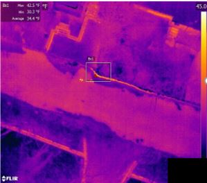
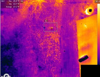
Findings:
- Permitted discharge – groundwater.
- Much smaller thermal signature compared to May, consistent with lack of groundwater (shot at low tide).
Observations:
- Noted drainage from roof drain or sump pump to storm drain.
- Apparent signs of roadwork, drain not shown in past years’ Google Street view.
- No surface indications of failing septic systems.
- Noted active outfall from rainfall earlier in morning.
If your community needs to improve its stormwater management concerning MS4, SWPPP, and SPDES, Walden can help.
For more information about Walden’s use of drone technology on projects, please review our drone guide and visit our blog Industrial Stormwater Pollution in MS4 Areas.
Walden welcomes the opportunity to discuss projects such as these. If you have any questions or need assistance with your municipalities and other projects, please contact us today at 518-490-4821.