
Walden and Harkin Aerial will be presenting groundbreaking techniques for using drones to locate potential pollution in water bodies at the 2021 Long Island GIS Virtual User Conference. The seminar will discuss using cutting-edge technology to find illicit discharges.
Thomas T. (Ted), Nitza Jr., P.E. from Walden, and Scott Harrigan from Harkin Aerial will be speaking at 12:00–12:30 pm on Thursday, April 29. Long Island Geographic Information Systems User Group (LIGIS) will be hosting the Conference for public works officials, municipal engineers, and GIS professionals.
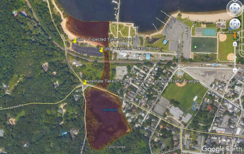
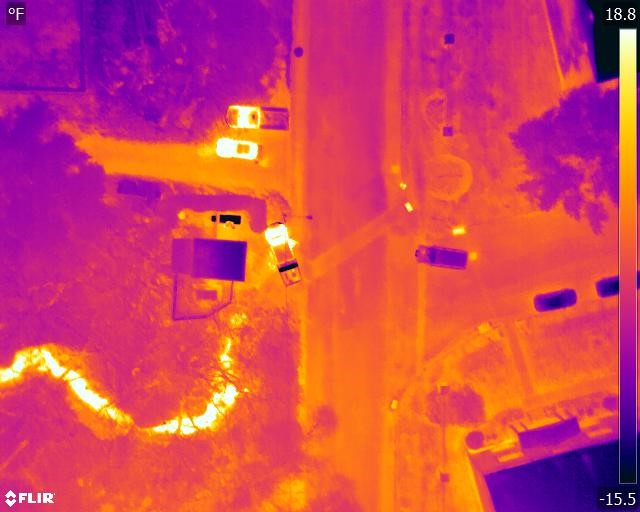
Nitza and Harrigan will be introducing emerging techniques for finding and assessing illicit discharges through the use of drones with thermal cameras. Walden and Harkin have completed several such inspections for MS4 communities in New York and will discuss the results, reporting format, and other deliverables. They will talk about methodology, equipment, findings, and next steps in building a “visual database” of thermal signatures related to different types of discharge profiles. Additionally, photo geo-referencing, integration into ArcGIS, and drone photogrammetry will be demonstrated as an aid to mapping and identifying illicit discharges. There will be a Q&A session from 12:30–12:50 pm.
Ross Baldwin, Long Island GIS Chairman, is organizing the virtual Conference of geospatial professionals. The presentations will range from local GIS programs to industry-leading geospatial representatives.
Walden and Harkin are growing in these areas of innovation and emerging markets. Walden combines the expertise and creativity of its employees to find new opportunities to benefit clients, the communities we serve and push the industry forward.
“Walden’s efforts include cutting edge technologies and developing new and creative ways to solve our engineering challenges. Walden encourages curiosity and favors an attitude seeking continual learning and improvement–resulting in an interesting place to develop your career further.”
Ted Nitza, P.E.
Walden’s other projects in the area of Research and Development can be reviewed on our web page that showcases new ideas and innovation.
If you are interested in attending the 2021 Long Island GIS Virtual User Conference, please register here. There is no cost to attend this year.
To read more about Walden’s work in this area, visit our blog Using Drones for MS4 Illicit Discharge Detection Investigations and Several Completed MS4 Studies Using Drones.
If you would like to learn more about Walden’s stormwater quality research and development efforts, contact us at (516) 624-7200 today.