
NYSDEC Superfund Site New Cassel, NY. Walden Associates has been the principal site investigation and remedial system design engineer for this New York State Superfund site since the NYSDEC-led RI/ FS was completed and the Record of Decision (ROD) was issued in 2000. The ROD required soil and sediment removal from on-site dry wells, installation of a soil vapor extraction/air sparging system across a wide source area, and installation of a groundwater circulation well system to treat and prevent off-site migration of VOC- contaminated groundwater. Walden’s past and continuing services include:
- Continues to manage the largest NYSDEC-led Superfund site within the New Cassel Industrial Area.
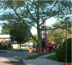
- Implemented a remedial program which included the drilling and sampling of over 20 groundwater and soil sampling profile borings to depths up to 250 feet below grade, based on remedial design and PRP search goals.
- Oversaw the drilling of a series of deep groundwater profiling borings to support the design of the remedial systems selected by NYSDEC and to further characterize the groundwater plume and evaluate contaminant contributions from off-site sources.
The profiling results indicated that groundwater collected above the clay layer from borings downgradient of on-site source areas contained greater concentrations of PCE than TCE, leading to the conclusion that groundwater below the clay was undoubtedly impacted by off-site sources of VOCs. Installed site-related monitoring wells at multiple depths, up to 250 feet below grade and continues to collect groundwater samples on a quarterly basis from up to 29 site-related monitoring wells under strict NYSDEC CLP sampling protocols using an NCP-compliant QA/QC plan. Designed and installed an air sparge/soil vapor extraction system to remove VOCs from on-site source areas. Design and piloted a groundwater cutoff and treatment system using in-well strippers to treat groundwater collected by six groundwater circulation wells. Maintains an EQuIS-based GIS environmental database system to facilitate date review, analysis and reporting to track remedial progress and fulfillment of regulatory milestones. Responsible for weekly implementation of project OMM Plan. Conducted further source area delineation work to identify area of perched DNAPL VOCs, utilizing a combination of geophysical tools and geoprobe soil/water sampling.