
It was not too many years ago that using laser scanners to capture space measurements was something that many organizations thought was out of their reach. Although the technology produces extremely accurate images, the costs associated with procuring the equipment were prohibitive, even through renting or leasing.
Thanks to ever-improving efficiencies in the technology, ground-based laser scanning and photogrammetry (known collectively as 3D scanning) have become more budget-friendly and within reach of organizations. However, first, it is important to understand what the technology is, how it is used, and what advantages it brings to engineering.
Previously, traditional means to take measurements of structures and land required personnel who would “shoot” (identify) points on a property or building and directly measure the distances between those points, one by one. This method, while accurate, can be time-consuming, tedious, and opens up the potential for human errors within each measurement.
How Does Ground-Based Laser Scanning Work?
Ground-based laser scanning is ideal for measuring entire structures quickly, both inside and outside.
An operator can set up the laser on a tripod or use a handheld unit and walk around the building with it. The scanner “fires” a laser that captures measurements of the space. The laser takes highly accurate measurements as it scans – up to 300,000 points per second, which significantly reduces the chance for human error, and reduces time on site.
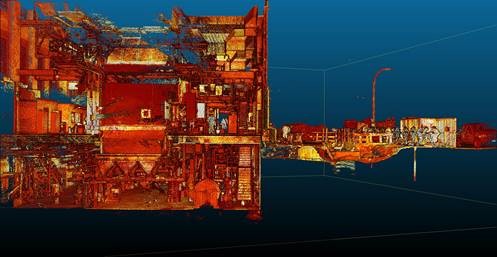
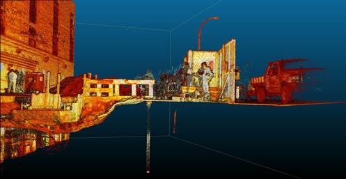
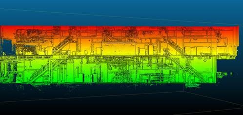
Typically, tripod-based laser scanners are used to measure buildings, especially from the inside, where they produce the highest quality scans. When complete, the operator downloads the data from the scanner to a computer and loads them into software that processes the scans. All of the scans are brought together to create a point cloud, which is a 3D representation. Engineers can then use this image as the basis to create AutoCAD drawings. Often, panoramic images of the building are supplied as additional deliverables.
What Are Some Important Considerations with This Type of Scanning?
While laser scanning creates incredibly detailed images, the raw data is often cumbersome to view without high-end hardware, and file sizes can be too large to send to a client or partner. Often a laser scan can actually have “too much” data that must be cleaned, stitched, and interpreted by a trained professional.
Therefore, when considering laser scanning, it is important to have engineers on hand that can understand what they see in a point cloud, and extrapolate the pertinent information needed for a task. Organizations that use ground-based laser scanning must be adept at creating an end product, such as a CAD drawing, that can be used for a variety of purposes in engineering work, or the advantages of using the technology could be lost.
Unfortunately, many organizations with laser scanners fall short of client expectations because they do not know or understand what to do with the images they have taken. It is important to understand that expertise in producing laser scans does not necessarily equal expertise on the end-product. For example, a laser scan that is required for environmental remediation should be performed by a knowledgeable engineering team with experience in remediation and laser scanning.
Walden has a strategic partnership with Harkin Aerial to provide clients with laser scanning services through the entire workflow of any project, from site capture, to processing, to producing professional, stamped engineering documents that fulfill your project requirements.
Why Use Ground-Based Laser Scanning?
Beyond the increased accuracy of ground-based laser scanning, there are numerous other benefits to using such technology. For example, to measure a ceiling, a person does not have to climb a ladder or climb into equipment that could create a risk of a fall from heights.
Also, if there are hazardous substances in the area that needs to get measured, such as asbestos, the operator does not have to touch anything or come into contact with a dangerous substance. As a result, the scanner can do the work without causing any risk to the operator or staff on site.
Finally, the amount of time an operator must spend on a site is decreased because the ground-based laser scanner can perform the work fast and produce accurate results within a centimeter or 1/8 inch, in both color and 3D.
Walden and Harkin have worked together on several projects and continue to be at the forefront of using technology to provide clients with value-added solutions to their most challenging engineering needs. Contact Walden at 516-271-1948 for more information.