
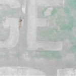
Drones have an exceptional ability to get into hard to reach and tight locations easily. Whether it is the rooftop on a water treatment plant or the envelope of an elevated water tank, drones combined with high powered zoom lenses are able to quickly inspect issues close-up. In the photo below, a drone was able to take off, circle the water tower, and take a photo of the area of concern in under 20 minutes. Compare that against the time it takes to have an inspector set up proper rigging and climb the side of a tower, which can take hours depending on the size of the structure. Additionally, by using drones instead of climbers, the liability associated with the operation is considerably lower. It is an unfortunate but relevant statistic that falls from height continue to be the largest single cause of on-site worker fatalities according to OSHA statistics. By using a drone for any inspections that do not require a “hands-on” component, this category of risk is eliminated entirely.
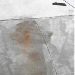
Using zoom lenses on a drone, extreme close-up photos of water tanks can be taken to inspect the exterior of the tank, down to the paint job. Details as small as 1/2” can be picked up by flying close and zooming in. In this example, the photo on the left was taken to ensure that installed patching tape was still in place as the tank was undergoing repairs. By removing the need for a rigger/climber, the inspection is considerably quicker and safer.
ALL FLYING, NO CONTACT
With recent restrictions due to COVID-19, drones are also an excellent way to investigate an entire site in a contact-free manner. All setup and piloting involves surfaces that need only be touched by a single person, and a typical drone flight crew can carry out a site survey without any physical contact. Measurements are passive an require no contact between the drone and the subject of analysis. The drone itself is cleaned after each flight as part of its maintenance schedule, and all controls are wiped down between flights.
EXPERIENCE MATTERS, COVERAGE MATTERS
It is important to understand that drones and associated services vary considerably in size, cost, and complexity. Firms that offer drone services also vary in their specific skills and areas of expertise, so when hiring any team, be sure to ask about their previous experience in your type of project. A professional firm will send over resumes qualifications, previous projects, and examples of similar work to demonstrate their level of familiarity and give you confidence that they are able to complete the work. Lastly, a great drone operator may be able to fly the aircraft, but you should be clear about who is analyzing and collecting the data, if required. For example, for the thermal work discussed, the project should be completed by at least an ITC Level 1 Thermographer, who is qualified to properly analyze thermal images. As mentioned, payloads vary significantly and experience with the drone does not always equate to experience with the payload or data collection workflow.
Additionally, the firm should have sufficient insurance liability policies in force while the drone is operated on your site. You should ask any firm you hire to provide proof of a specific unmanned aviation liability policy in addition your organization’s standard insurance requirements: general and professional policies liability do not typically extend to the use of drones.
WAIVERS, OTHER PAYLOADS, AND MORE
As you continue to take advantage of drone data, you may encounter scenarios where additional operational waivers are required from the FAA. For example, night flying is prohibited by the FAA for commercial uses by default, but drone-savvy firms, including Walden and Harkin, have obtained a 107.29 Daylight Waiver from the FAA allowing operation at night anywhere across the continental US. This is vital to thermal imaging, where sunlight adversely affects results. In the future, regulatory guidance is expected to enable flying Beyond Visual Line of Sight (BVLOS), which will allow drones to be deployed on long-range missions such as long water main runs, pipelines, or electrical transmission/distribution lines.
Additionally, LIDAR is becoming a more viable option for obtaining elevation data in heavily forested zones, due to decreasing hardware costs. Using a properly trained LIDAR technician and drone pilot, an area that may be impossible to measure via traditional surveying can now be easily scanned from the air. Unlike photogrammetry mapping, LIDAR is an active sensor that can operate even in low-light conditions. This powerful technology has been used even to uncover previously lost ancient cities. Other technologies are quickly becoming readily available as well, such as methane detection, and aerial Ground Penetrating Radar. Walden and Harkin are continually testing new payloads and work-flows to offer new modes of data collection and increased efficiency on site.
Stay tuned for more information on Walden’s GUIDE TO DRONES IN ENVIRONMENTAL ENGINEERING: How Drones Are Mapping Sites, Improving Water Quality & Managing Infrastructure.